Loading map...
{"minzoom":false,"maxzoom":false,"mappingservice":"leaflet","width":"auto","height":"600px","centre":{"text":"","title":"","link":"","lat":51.197453,"lon":0.271428,"icon":""},"title":"","label":"","icon":"","lines":[],"polygons":[],"circles":[],"rectangles":[],"copycoords":false,"static":false,"zoom":false,"defzoom":14,"layers":["OpenStreetMap","Esri.WorldImagery"],"image layers":[],"overlays":[],"resizable":false,"fullscreen":true,"scrollwheelzoom":true,"cluster":false,"clustermaxzoom":20,"clusterzoomonclick":true,"clustermaxradius":1,"clusterspiderfy":true,"geojson":"","clicktarget":"","imageLayers":[],"locations":[{"text":"\u003Cb\u003E\u003Cdiv class=\"mw-parser-output\"\u003E\u003Cp\u003E\u003Ca href=\"/northfleet-kilns\" title=\"northfleet-kilns\"\u003ENorthfleet Kilns\u003C/a\u003E\u003C/b\u003E\u003Cdiv class=\"mw-parser-output\"\u003E\u003Cp\u003E\u003Ca href=\"/Category:factories-and-storage\" title=\"Category:factories-and-storage\"\u003EFactories and Storage\u003C/a\u003E, \u003Ca href=\"/Category:civil-defence\" title=\"Category:civil-defence\"\u003ECivil Defence\u003C/a\u003E, \u003Ca href=\"/Category:transport\" title=\"Category:transport\"\u003ETransport\u003C/a\u003E\n\u003C/p\u003E\u003C/div\u003E","title":"Northfleet Kilns@Factories and Storage, Civil Defence, Transport\n","link":"","lat":51.448,"lon":0.329,"icon":"/images/4/40/m_factories-and-storage.png"},{"text":"\u003Cb\u003E\u003Cdiv class=\"mw-parser-output\"\u003E\u003Cp\u003E\u003Ca href=\"/hollingbourne-zero-station-auxiliary-units\" title=\"hollingbourne-zero-station-auxiliary-units\"\u003EHollingbourne Zero Station (Auxiliary Units)\u003C/a\u003E\u003C/b\u003E\u003Cdiv class=\"mw-parser-output\"\u003E\u003Cp\u003E\u003Ca href=\"/Category:military-land\" title=\"Category:military-land\"\u003EMilitary - Land\u003C/a\u003E\n\u003C/p\u003E\u003C/div\u003E","title":"Hollingbourne Zero Station (Auxiliary Units)@Military - Land\n","link":"","lat":51.269,"lon":0.671,"icon":"/images/2/2c/m_military-land.png"},{"text":"\u003Cb\u003E\u003Cdiv class=\"mw-parser-output\"\u003E\u003Cp\u003E\u003Ca href=\"/coldblow-ace-high-relay-station\" title=\"coldblow-ace-high-relay-station\"\u003EColdblow Ace High Relay Station\u003C/a\u003E\u003C/b\u003E\u003Cdiv class=\"mw-parser-output\"\u003E\u003Cp\u003E\u003Ca href=\"/Category:radar\" title=\"Category:radar\"\u003ERadar\u003C/a\u003E\n\u003C/p\u003E\u003C/div\u003E","title":"Coldblow Ace High Relay Station@Radar\n","link":"","lat":51.296,"lon":0.615,"icon":"/images/e/ef/m_radar.png"},{"text":"\u003Cb\u003E\u003Cdiv class=\"mw-parser-output\"\u003E\u003Cp\u003E\u003Ca href=\"/chatham-southern-water-emergency-control-centre\" title=\"chatham-southern-water-emergency-control-centre\"\u003EChatham Southern Water Emergency Control Centre\u003C/a\u003E\u003C/b\u003E\u003Cdiv class=\"mw-parser-output\"\u003E\u003Cp\u003E\u003Ca href=\"/Category:nuclear-bunkers\" title=\"Category:nuclear-bunkers\"\u003ENuclear Bunkers\u003C/a\u003E, \u003Ca href=\"/Category:sewers-sanitation-and-water\" title=\"Category:sewers-sanitation-and-water\"\u003ESewers, Sanitation and Water\u003C/a\u003E\n\u003C/p\u003E\u003C/div\u003E","title":"Chatham Southern Water Emergency Control Centre@Nuclear Bunkers, Sewers, Sanitation and Water\n","link":"","lat":51.337,"lon":0.613,"icon":"/images/d/d0/m_nuclear-bunkers.png"},{"text":"\u003Cb\u003E\u003Cdiv class=\"mw-parser-output\"\u003E\u003Cp\u003E\u003Ca href=\"/hoo-fort\" title=\"hoo-fort\"\u003EHoo Fort\u003C/a\u003E\u003C/b\u003E\u003Cdiv class=\"mw-parser-output\"\u003E\u003Cp\u003E\u003Ca href=\"/Category:military-land\" title=\"Category:military-land\"\u003EMilitary - Land\u003C/a\u003E\n\u003C/p\u003E\u003C/div\u003E","title":"Hoo Fort@Military - Land\n","link":"","lat":51.403,"lon":0.582,"icon":"/images/2/2c/m_military-land.png"},{"text":"\u003Cb\u003E\u003Cdiv class=\"mw-parser-output\"\u003E\u003Cp\u003E\u003Ca href=\"/darnley-mausoleum\" title=\"darnley-mausoleum\"\u003EDarnley Mausoleum\u003C/a\u003E\u003C/b\u003E\u003Cdiv class=\"mw-parser-output\"\u003E\u003Cp\u003E\u003Ca href=\"/Category:places-to-visit\" title=\"Category:places-to-visit\"\u003EPlaces To Visit\u003C/a\u003E, \u003Ca href=\"/Category:religious-and-burial\" title=\"Category:religious-and-burial\"\u003EReligious and Burial\u003C/a\u003E\n\u003C/p\u003E\u003C/div\u003E","title":"Darnley Mausoleum@Places To Visit, Religious and Burial\n","link":"","lat":51.389,"lon":0.434,"icon":"v_places-to-visit.png"},{"text":"\u003Cb\u003E\u003Cdiv class=\"mw-parser-output\"\u003E\u003Cp\u003E\u003Ca href=\"/tenterden-roc-post\" title=\"tenterden-roc-post\"\u003ETenterden ROC Post\u003C/a\u003E\u003C/b\u003E\u003Cdiv class=\"mw-parser-output\"\u003E\u003Cp\u003E\u003Ca href=\"/Category:nuclear-monitoring-posts\" title=\"Category:nuclear-monitoring-posts\"\u003ENuclear Monitoring Posts\u003C/a\u003E\n\u003C/p\u003E\u003C/div\u003E","title":"Tenterden ROC Post@Nuclear Monitoring Posts\n","link":"","lat":51.082,"lon":0.673,"icon":"/images/4/4c/m_nuclear-monitoring-posts.png"},{"text":"\u003Cb\u003E\u003Cdiv class=\"mw-parser-output\"\u003E\u003Cp\u003E\u003Ca href=\"/rainham-kent-roc-post\" title=\"rainham-kent-roc-post\"\u003ERainham (Kent) ROC Post\u003C/a\u003E\u003C/b\u003E\u003Cdiv class=\"mw-parser-output\"\u003E\u003Cp\u003E\u003Ca href=\"/Category:nuclear-monitoring-posts\" title=\"Category:nuclear-monitoring-posts\"\u003ENuclear Monitoring Posts\u003C/a\u003E\n\u003C/p\u003E\u003C/div\u003E","title":"Rainham (Kent) ROC Post@Nuclear Monitoring Posts\n","link":"","lat":51.351,"lon":0.611,"icon":"/images/4/4c/m_nuclear-monitoring-posts.png"},{"text":"\u003Cb\u003E\u003Cdiv class=\"mw-parser-output\"\u003E\u003Cp\u003E\u003Ca href=\"/penshurst-roc-post\" title=\"penshurst-roc-post\"\u003EPenshurst ROC Post\u003C/a\u003E\u003C/b\u003E\u003Cdiv class=\"mw-parser-output\"\u003E\u003Cp\u003E\u003Ca href=\"/Category:nuclear-monitoring-posts\" title=\"Category:nuclear-monitoring-posts\"\u003ENuclear Monitoring Posts\u003C/a\u003E\n\u003C/p\u003E\u003C/div\u003E","title":"Penshurst ROC Post@Nuclear Monitoring Posts\n","link":"","lat":51.202,"lon":0.183,"icon":"/images/4/4c/m_nuclear-monitoring-posts.png"},{"text":"\u003Cb\u003E\u003Cdiv class=\"mw-parser-output\"\u003E\u003Cp\u003E\u003Ca href=\"/linton-roc-post\" title=\"linton-roc-post\"\u003ELinton ROC Post\u003C/a\u003E\u003C/b\u003E\u003Cdiv class=\"mw-parser-output\"\u003E\u003Cp\u003E\u003Ca href=\"/Category:nuclear-monitoring-posts\" title=\"Category:nuclear-monitoring-posts\"\u003ENuclear Monitoring Posts\u003C/a\u003E\n\u003C/p\u003E\u003C/div\u003E","title":"Linton ROC Post@Nuclear Monitoring Posts\n","link":"","lat":51.231,"lon":0.525,"icon":"/images/4/4c/m_nuclear-monitoring-posts.png"},{"text":"\u003Cb\u003E\u003Cdiv class=\"mw-parser-output\"\u003E\u003Cp\u003E\u003Ca href=\"/farningham-roc-post\" title=\"farningham-roc-post\"\u003EFarningham ROC Post\u003C/a\u003E\u003C/b\u003E\u003Cdiv class=\"mw-parser-output\"\u003E\u003Cp\u003E\u003Ca href=\"/Category:nuclear-monitoring-posts\" title=\"Category:nuclear-monitoring-posts\"\u003ENuclear Monitoring Posts\u003C/a\u003E\n\u003C/p\u003E\u003C/div\u003E","title":"Farningham ROC Post@Nuclear Monitoring Posts\n","link":"","lat":51.381,"lon":0.202,"icon":"/images/4/4c/m_nuclear-monitoring-posts.png"},{"text":"\u003Cb\u003E\u003Cdiv class=\"mw-parser-output\"\u003E\u003Cp\u003E\u003Ca href=\"/edenbridge-roc-post\" title=\"edenbridge-roc-post\"\u003EEdenbridge ROC Post\u003C/a\u003E\u003C/b\u003E\u003Cdiv class=\"mw-parser-output\"\u003E\u003Cp\u003E\u003Ca href=\"/Category:nuclear-monitoring-posts\" title=\"Category:nuclear-monitoring-posts\"\u003ENuclear Monitoring Posts\u003C/a\u003E\n\u003C/p\u003E\u003C/div\u003E","title":"Edenbridge ROC Post@Nuclear Monitoring Posts\n","link":"","lat":51.198,"lon":0.087,"icon":"/images/4/4c/m_nuclear-monitoring-posts.png"},{"text":"\u003Cb\u003E\u003Cdiv class=\"mw-parser-output\"\u003E\u003Cp\u003E\u003Ca href=\"/cranbrook-roc-post\" title=\"cranbrook-roc-post\"\u003ECranbrook ROC Post\u003C/a\u003E\u003C/b\u003E\u003Cdiv class=\"mw-parser-output\"\u003E\u003Cp\u003E\u003Ca href=\"/Category:nuclear-monitoring-posts\" title=\"Category:nuclear-monitoring-posts\"\u003ENuclear Monitoring Posts\u003C/a\u003E\n\u003C/p\u003E\u003C/div\u003E","title":"Cranbrook ROC Post@Nuclear Monitoring Posts\n","link":"","lat":51.091,"lon":0.516,"icon":"/images/4/4c/m_nuclear-monitoring-posts.png"},{"text":"\u003Cb\u003E\u003Cdiv class=\"mw-parser-output\"\u003E\u003Cp\u003E\u003Ca href=\"/cliffe-roc-post\" title=\"cliffe-roc-post\"\u003ECliffe ROC Post\u003C/a\u003E\u003C/b\u003E\u003Cdiv class=\"mw-parser-output\"\u003E\u003Cp\u003E\u003Ca href=\"/Category:nuclear-monitoring-posts\" title=\"Category:nuclear-monitoring-posts\"\u003ENuclear Monitoring Posts\u003C/a\u003E\n\u003C/p\u003E\u003C/div\u003E","title":"Cliffe ROC Post@Nuclear Monitoring Posts\n","link":"","lat":51.461,"lon":0.492,"icon":"/images/4/4c/m_nuclear-monitoring-posts.png"},{"text":"\u003Cb\u003E\u003Cdiv class=\"mw-parser-output\"\u003E\u003Cp\u003E\u003Ca href=\"/borough-green-roc-post\" title=\"borough-green-roc-post\"\u003EBorough Green ROC Post\u003C/a\u003E\u003C/b\u003E\u003Cdiv class=\"mw-parser-output\"\u003E\u003Cp\u003E\u003Ca href=\"/Category:nuclear-monitoring-posts\" title=\"Category:nuclear-monitoring-posts\"\u003ENuclear Monitoring Posts\u003C/a\u003E\n\u003C/p\u003E\u003C/div\u003E","title":"Borough Green ROC Post@Nuclear Monitoring Posts\n","link":"","lat":51.292,"lon":0.312,"icon":"/images/4/4c/m_nuclear-monitoring-posts.png"},{"text":"\u003Cb\u003E\u003Cdiv class=\"mw-parser-output\"\u003E\u003Cp\u003E\u003Ca href=\"/fort-pitt\" title=\"fort-pitt\"\u003EFort Pitt\u003C/a\u003E\u003C/b\u003E\u003Cdiv class=\"mw-parser-output\"\u003E\u003Cp\u003E\u003Ca href=\"/Category:civil-defence\" title=\"Category:civil-defence\"\u003ECivil Defence\u003C/a\u003E, \u003Ca href=\"/Category:military-land\" title=\"Category:military-land\"\u003EMilitary - Land\u003C/a\u003E\n\u003C/p\u003E\u003C/div\u003E","title":"Fort Pitt@Civil Defence, Military - Land\n","link":"","lat":51.382,"lon":0.514,"icon":"/images/c/c5/m_civil-defence.png"},{"text":"\u003Cb\u003E\u003Cdiv class=\"mw-parser-output\"\u003E\u003Cp\u003E\u003Ca href=\"/st-matthews-school-air-raid-shelter\" title=\"st-matthews-school-air-raid-shelter\"\u003ESt Matthews School Air Raid Shelter\u003C/a\u003E\u003C/b\u003E\u003Cdiv class=\"mw-parser-output\"\u003E\u003Cp\u003E\u003Ca href=\"/Category:civil-defence\" title=\"Category:civil-defence\"\u003ECivil Defence\u003C/a\u003E, \u003Ca href=\"/Category:places-to-visit\" title=\"Category:places-to-visit\"\u003EPlaces To Visit\u003C/a\u003E\n\u003C/p\u003E\u003C/div\u003E","title":"St Matthews School Air Raid Shelter@Civil Defence, Places To Visit\n","link":"","lat":51.153,"lon":0.271,"icon":"/images/3/3e/v_civil-defence.png"},{"text":"\u003Cb\u003E\u003Cdiv class=\"mw-parser-output\"\u003E\u003Cp\u003E\u003Ca href=\"/civil-defence-control-centre-gravesend\" title=\"civil-defence-control-centre-gravesend\"\u003ECivil Defence Control Centre Gravesend\u003C/a\u003E\u003C/b\u003E\u003Cdiv class=\"mw-parser-output\"\u003E\u003Cp\u003E\u003Ca href=\"/Category:military-intelligence-and-communication\" title=\"Category:military-intelligence-and-communication\"\u003EMilitary - Intelligence and Communication\u003C/a\u003E, \u003Ca href=\"/Category:places-to-visit\" title=\"Category:places-to-visit\"\u003EPlaces To Visit\u003C/a\u003E\n\u003C/p\u003E\u003C/div\u003E","title":"Civil Defence Control Centre Gravesend@Military - Intelligence and Communication, Places To Visit\n","link":"","lat":51.431,"lon":0.364,"icon":"/images/6/63/v_military-intelligence-and-communication.png"},{"text":"\u003Cb\u003E\u003Cdiv class=\"mw-parser-output\"\u003E\u003Cp\u003E\u003Ca href=\"/hosey-common-stone-quarry\" title=\"hosey-common-stone-quarry\"\u003EHosey Common Stone Quarry\u003C/a\u003E\u003C/b\u003E\u003Cdiv class=\"mw-parser-output\"\u003E\u003Cp\u003E\u003Ca href=\"/Category:mines\" title=\"Category:mines\"\u003EMines\u003C/a\u003E\n\u003C/p\u003E\u003C/div\u003E","title":"Hosey Common Stone Quarry@Mines\n","link":"","lat":51.256,"lon":0.084,"icon":"/images/a/ae/m_mines.png"},{"text":"\u003Cb\u003E\u003Cdiv class=\"mw-parser-output\"\u003E\u003Cp\u003E\u003Ca href=\"/west-malling-airfield-battle-hq\" title=\"west-malling-airfield-battle-hq\"\u003EWest Malling Airfield Battle HQ\u003C/a\u003E\u003C/b\u003E\u003Cdiv class=\"mw-parser-output\"\u003E\u003Cp\u003E\u003Ca href=\"/Category:military-air\" title=\"Category:military-air\"\u003EMilitary - Air\u003C/a\u003E\n\u003C/p\u003E\u003C/div\u003E","title":"West Malling Airfield Battle HQ@Military - Air\n","link":"","lat":51.265,"lon":0.402,"icon":"/images/4/4e/m_military-air.png"},{"text":"\u003Cb\u003E\u003Cdiv class=\"mw-parser-output\"\u003E\u003Cp\u003E\u003Ca href=\"/detling-airfield-battle-hq\" title=\"detling-airfield-battle-hq\"\u003EDetling Airfield Battle HQ\u003C/a\u003E\u003C/b\u003E\u003Cdiv class=\"mw-parser-output\"\u003E\u003Cp\u003E\u003Ca href=\"/Category:military-air\" title=\"Category:military-air\"\u003EMilitary - Air\u003C/a\u003E\n\u003C/p\u003E\u003C/div\u003E","title":"Detling Airfield Battle HQ@Military - Air\n","link":"","lat":51.311,"lon":0.608,"icon":"/images/4/4e/m_military-air.png"},{"text":"\u003Cb\u003E\u003Cdiv class=\"mw-parser-output\"\u003E\u003Cp\u003E\u003Ca href=\"/grove-tunnel\" title=\"grove-tunnel\"\u003EGrove Tunnel\u003C/a\u003E\u003C/b\u003E\u003Cdiv class=\"mw-parser-output\"\u003E\u003Cp\u003E\u003Ca href=\"/Category:transport\" title=\"Category:transport\"\u003ETransport\u003C/a\u003E\n\u003C/p\u003E\u003C/div\u003E","title":"Grove Tunnel@Transport\n","link":"","lat":51.123,"lon":0.258,"icon":"/images/5/57/m_transport.png"},{"text":"\u003Cb\u003E\u003Cdiv class=\"mw-parser-output\"\u003E\u003Cp\u003E\u003Ca href=\"/tunbridge-wells-regional-war-room\" title=\"tunbridge-wells-regional-war-room\"\u003ETunbridge Wells Regional War Room\u003C/a\u003E\u003C/b\u003E\u003Cdiv class=\"mw-parser-output\"\u003E\u003Cp\u003E\u003Ca href=\"/Category:government-national-and-regional\" title=\"Category:government-national-and-regional\"\u003EGovernment - National and Regional\u003C/a\u003E, \u003Ca href=\"/Category:nuclear-bunkers\" title=\"Category:nuclear-bunkers\"\u003ENuclear Bunkers\u003C/a\u003E\n\u003C/p\u003E\u003C/div\u003E","title":"Tunbridge Wells Regional War Room@Government - National and Regional, Nuclear Bunkers\n","link":"","lat":51.126,"lon":0.279,"icon":"/images/d/d7/m_government-national-and-regional.png"},{"text":"\u003Cb\u003E\u003Cdiv class=\"mw-parser-output\"\u003E\u003Cp\u003E\u003Ca href=\"/maidstone-springfields-kent-county-emergency-centre\" title=\"maidstone-springfields-kent-county-emergency-centre\"\u003EMaidstone Springfields Kent County Emergency Centre\u003C/a\u003E\u003C/b\u003E\u003Cdiv class=\"mw-parser-output\"\u003E\u003Cp\u003E\u003Ca href=\"/Category:government-local\" title=\"Category:government-local\"\u003EGovernment - Local\u003C/a\u003E, \u003Ca href=\"/Category:nuclear-bunkers\" title=\"Category:nuclear-bunkers\"\u003ENuclear Bunkers\u003C/a\u003E\n\u003C/p\u003E\u003C/div\u003E","title":"Maidstone Springfields Kent County Emergency Centre@Government - Local, Nuclear Bunkers\n","link":"","lat":51.285,"lon":0.516,"icon":"/images/3/32/m_government-local.png"},{"text":"\u003Cb\u003E\u003Cdiv class=\"mw-parser-output\"\u003E\u003Cp\u003E\u003Ca href=\"/gillingham-borough-control\" title=\"gillingham-borough-control\"\u003EGillingham Borough Control\u003C/a\u003E\u003C/b\u003E\u003Cdiv class=\"mw-parser-output\"\u003E\u003Cp\u003E\u003Ca href=\"/Category:government-local\" title=\"Category:government-local\"\u003EGovernment - Local\u003C/a\u003E, \u003Ca href=\"/Category:nuclear-bunkers\" title=\"Category:nuclear-bunkers\"\u003ENuclear Bunkers\u003C/a\u003E\n\u003C/p\u003E\u003C/div\u003E","title":"Gillingham Borough Control@Government - Local, Nuclear Bunkers\n","link":"","lat":51.376,"lon":0.553,"icon":"/images/3/32/m_government-local.png"},{"text":"\u003Cb\u003E\u003Cdiv class=\"mw-parser-output\"\u003E\u003Cp\u003E\u003Ca href=\"/dartford-emergency-centre\" title=\"dartford-emergency-centre\"\u003EDartford Emergency Centre\u003C/a\u003E\u003C/b\u003E\u003Cdiv class=\"mw-parser-output\"\u003E\u003Cp\u003E\u003Ca href=\"/Category:government-local\" title=\"Category:government-local\"\u003EGovernment - Local\u003C/a\u003E, \u003Ca href=\"/Category:nuclear-bunkers\" title=\"Category:nuclear-bunkers\"\u003ENuclear Bunkers\u003C/a\u003E\n\u003C/p\u003E\u003C/div\u003E","title":"Dartford Emergency Centre@Government - Local, Nuclear Bunkers\n","link":"","lat":51.447,"lon":0.219,"icon":"/images/3/32/m_government-local.png"},{"text":"\u003Cb\u003E\u003Cdiv class=\"mw-parser-output\"\u003E\u003Cp\u003E\u003Ca href=\"/darenth-wood-dene-hole\" title=\"darenth-wood-dene-hole\"\u003EDarenth Wood Dene Hole\u003C/a\u003E\u003C/b\u003E\u003Cdiv class=\"mw-parser-output\"\u003E\u003Cp\u003E\u003Ca href=\"/Category:mines\" title=\"Category:mines\"\u003EMines\u003C/a\u003E\n\u003C/p\u003E\u003C/div\u003E","title":"Darenth Wood Dene Hole@Mines\n","link":"","lat":51.43,"lon":0.267,"icon":"/images/a/ae/m_mines.png"},{"text":"\u003Cb\u003E\u003Cdiv class=\"mw-parser-output\"\u003E\u003Cp\u003E\u003Ca href=\"/wateringbury-roc-post\" title=\"wateringbury-roc-post\"\u003EWateringbury ROC Post\u003C/a\u003E\u003C/b\u003E\u003Cdiv class=\"mw-parser-output\"\u003E\u003Cp\u003E\u003Ca href=\"/Category:nuclear-monitoring-posts\" title=\"Category:nuclear-monitoring-posts\"\u003ENuclear Monitoring Posts\u003C/a\u003E\n\u003C/p\u003E\u003C/div\u003E","title":"Wateringbury ROC Post@Nuclear Monitoring Posts\n","link":"","lat":51.246,"lon":0.4,"icon":"/images/4/4c/m_nuclear-monitoring-posts.png"},{"text":"\u003Cb\u003E\u003Cdiv class=\"mw-parser-output\"\u003E\u003Cp\u003E\u003Ca href=\"/snodland-roc-post\" title=\"snodland-roc-post\"\u003ESnodland ROC Post\u003C/a\u003E\u003C/b\u003E\u003Cdiv class=\"mw-parser-output\"\u003E\u003Cp\u003E\u003Ca href=\"/Category:nuclear-monitoring-posts\" title=\"Category:nuclear-monitoring-posts\"\u003ENuclear Monitoring Posts\u003C/a\u003E\n\u003C/p\u003E\u003C/div\u003E","title":"Snodland ROC Post@Nuclear Monitoring Posts\n","link":"","lat":51.323,"lon":0.432,"icon":"/images/4/4c/m_nuclear-monitoring-posts.png"},{"text":"\u003Cb\u003E\u003Cdiv class=\"mw-parser-output\"\u003E\u003Cp\u003E\u003Ca href=\"/horsmonden-roc-post\" title=\"horsmonden-roc-post\"\u003EHorsmonden ROC Post\u003C/a\u003E\u003C/b\u003E\u003Cdiv class=\"mw-parser-output\"\u003E\u003Cp\u003E\u003Ca href=\"/Category:nuclear-monitoring-posts\" title=\"Category:nuclear-monitoring-posts\"\u003ENuclear Monitoring Posts\u003C/a\u003E\n\u003C/p\u003E\u003C/div\u003E","title":"Horsmonden ROC Post@Nuclear Monitoring Posts\n","link":"","lat":51.121,"lon":0.425,"icon":"/images/4/4c/m_nuclear-monitoring-posts.png"},{"text":"\u003Cb\u003E\u003Cdiv class=\"mw-parser-output\"\u003E\u003Cp\u003E\u003Ca href=\"/headcorn-roc-post\" title=\"headcorn-roc-post\"\u003EHeadcorn ROC Post\u003C/a\u003E\u003C/b\u003E\u003Cdiv class=\"mw-parser-output\"\u003E\u003Cp\u003E\u003Ca href=\"/Category:nuclear-monitoring-posts\" title=\"Category:nuclear-monitoring-posts\"\u003ENuclear Monitoring Posts\u003C/a\u003E\n\u003C/p\u003E\u003C/div\u003E","title":"Headcorn ROC Post@Nuclear Monitoring Posts\n","link":"","lat":51.171,"lon":0.616,"icon":"/images/4/4c/m_nuclear-monitoring-posts.png"},{"text":"\u003Cb\u003E\u003Cdiv class=\"mw-parser-output\"\u003E\u003Cp\u003E\u003Ca href=\"/greenhithe-roc-post\" title=\"greenhithe-roc-post\"\u003EGreenhithe ROC Post\u003C/a\u003E\u003C/b\u003E\u003Cdiv class=\"mw-parser-output\"\u003E\u003Cp\u003E\u003Ca href=\"/Category:nuclear-monitoring-posts\" title=\"Category:nuclear-monitoring-posts\"\u003ENuclear Monitoring Posts\u003C/a\u003E\n\u003C/p\u003E\u003C/div\u003E","title":"Greenhithe ROC Post@Nuclear Monitoring Posts\n","link":"","lat":51.437,"lon":0.312,"icon":"/images/4/4c/m_nuclear-monitoring-posts.png"},{"text":"\u003Cb\u003E\u003Cdiv class=\"mw-parser-output\"\u003E\u003Cp\u003E\u003Ca href=\"/brasted-roc-post\" title=\"brasted-roc-post\"\u003EBrasted ROC Post\u003C/a\u003E\u003C/b\u003E\u003Cdiv class=\"mw-parser-output\"\u003E\u003Cp\u003E\u003Ca href=\"/Category:nuclear-monitoring-posts\" title=\"Category:nuclear-monitoring-posts\"\u003ENuclear Monitoring Posts\u003C/a\u003E\n\u003C/p\u003E\u003C/div\u003E","title":"Brasted ROC Post@Nuclear Monitoring Posts\n","link":"","lat":51.29,"lon":0.106,"icon":"/images/4/4c/m_nuclear-monitoring-posts.png"},{"text":"\u003Cb\u003E\u003Cdiv class=\"mw-parser-output\"\u003E\u003Cp\u003E\u003Ca href=\"/bearsted-roc-post\" title=\"bearsted-roc-post\"\u003EBearsted ROC Post\u003C/a\u003E\u003C/b\u003E\u003Cdiv class=\"mw-parser-output\"\u003E\u003Cp\u003E\u003Ca href=\"/Category:nuclear-monitoring-posts\" title=\"Category:nuclear-monitoring-posts\"\u003ENuclear Monitoring Posts\u003C/a\u003E\n\u003C/p\u003E\u003C/div\u003E","title":"Bearsted ROC Post@Nuclear Monitoring Posts\n","link":"","lat":51.275,"lon":0.573,"icon":"/images/4/4c/m_nuclear-monitoring-posts.png"},{"text":"\u003Cb\u003E\u003Cdiv class=\"mw-parser-output\"\u003E\u003Cp\u003E\u003Ca href=\"/fort-bridgewoods-aaor\" title=\"fort-bridgewoods-aaor\"\u003EFort Bridgewoods AAOR\u003C/a\u003E\u003C/b\u003E\u003Cdiv class=\"mw-parser-output\"\u003E\u003Cp\u003E\u003Ca href=\"/Category:military-land\" title=\"Category:military-land\"\u003EMilitary - Land\u003C/a\u003E, \u003Ca href=\"/Category:nuclear-bunkers\" title=\"Category:nuclear-bunkers\"\u003ENuclear Bunkers\u003C/a\u003E\n\u003C/p\u003E\u003C/div\u003E","title":"Fort Bridgewoods AAOR@Military - Land, Nuclear Bunkers\n","link":"","lat":51.36,"lon":0.494,"icon":"/images/2/2c/m_military-land.png"},{"text":"\u003Cb\u003E\u003Cdiv class=\"mw-parser-output\"\u003E\u003Cp\u003E\u003Ca href=\"/lullingstone-castle-ice-house\" title=\"lullingstone-castle-ice-house\"\u003ELullingstone Castle Ice House\u003C/a\u003E\u003C/b\u003E\u003Cdiv class=\"mw-parser-output\"\u003E\u003Cp\u003E\u003Ca href=\"/Category:ice-wells\" title=\"Category:ice-wells\"\u003EIce Wells\u003C/a\u003E\n\u003C/p\u003E\u003C/div\u003E","title":"Lullingstone Castle Ice House@Ice Wells\n","link":"","lat":51.357,"lon":0.198,"icon":"/images/d/d4/m_ice-wells.png"},{"text":"\u003Cb\u003E\u003Cdiv class=\"mw-parser-output\"\u003E\u003Cp\u003E\u003Ca href=\"/chatham-dockyard-commissioners-house\" title=\"chatham-dockyard-commissioners-house\"\u003EChatham Dockyard Commissioner's House Ice House\u003C/a\u003E\u003C/b\u003E\u003Cdiv class=\"mw-parser-output\"\u003E\u003Cp\u003E\u003Ca href=\"/Category:ice-wells\" title=\"Category:ice-wells\"\u003EIce Wells\u003C/a\u003E\n\u003C/p\u003E\u003C/div\u003E","title":"Chatham Dockyard Commissioner's House Ice House@Ice Wells\n","link":"","lat":51.394,"lon":0.527,"icon":"/images/d/d4/m_ice-wells.png"},{"text":"\u003Cb\u003E\u003Cdiv class=\"mw-parser-output\"\u003E\u003Cp\u003E\u003Ca href=\"/knole-house-ice-well\" title=\"knole-house-ice-well\"\u003EKnole House Ice Well\u003C/a\u003E\u003C/b\u003E\u003Cdiv class=\"mw-parser-output\"\u003E\u003Cp\u003E\u003Ca href=\"/Category:ice-wells\" title=\"Category:ice-wells\"\u003EIce Wells\u003C/a\u003E\n\u003C/p\u003E\u003C/div\u003E","title":"Knole House Ice Well@Ice Wells\n","link":"","lat":51.266,"lon":0.206,"icon":"/images/d/d4/m_ice-wells.png"},{"text":"\u003Cb\u003E\u003Cdiv class=\"mw-parser-output\"\u003E\u003Cp\u003E\u003Ca href=\"/hms-wildfire\" title=\"hms-wildfire\"\u003EHMS Wildfire\u003C/a\u003E\u003C/b\u003E\u003Cdiv class=\"mw-parser-output\"\u003E\u003Cp\u003E\u003Ca href=\"/Category:military-sea\" title=\"Category:military-sea\"\u003EMilitary - Sea\u003C/a\u003E, \u003Ca href=\"/Category:military-air\" title=\"Category:military-air\"\u003EMilitary - Air\u003C/a\u003E\n\u003C/p\u003E\u003C/div\u003E","title":"HMS Wildfire@Military - Sea, Military - Air\n","link":"","lat":51.395,"lon":0.544,"icon":"/images/6/6b/m_military-sea.png"},{"text":"\u003Cb\u003E\u003Cdiv class=\"mw-parser-output\"\u003E\u003Cp\u003E\u003Ca href=\"/hoo-roc-post\" title=\"hoo-roc-post\"\u003EHoo ROC Post\u003C/a\u003E\u003C/b\u003E\u003Cdiv class=\"mw-parser-output\"\u003E\u003Cp\u003E\u003Ca href=\"/Category:nuclear-monitoring-posts\" title=\"Category:nuclear-monitoring-posts\"\u003ENuclear Monitoring Posts\u003C/a\u003E\n\u003C/p\u003E\u003C/div\u003E","title":"Hoo ROC Post@Nuclear Monitoring Posts\n","link":"","lat":51.432,"lon":0.557,"icon":"/images/4/4c/m_nuclear-monitoring-posts.png"},{"text":"\u003Cb\u003E\u003Cdiv class=\"mw-parser-output\"\u003E\u003Cp\u003E\u003Ca href=\"/fort-amherst\" title=\"fort-amherst\"\u003EFort Amherst\u003C/a\u003E\u003C/b\u003E\u003Cdiv class=\"mw-parser-output\"\u003E\u003Cp\u003E\u003Ca href=\"/Category:military-land\" title=\"Category:military-land\"\u003EMilitary - Land\u003C/a\u003E, \u003Ca href=\"/Category:places-to-visit\" title=\"Category:places-to-visit\"\u003EPlaces To Visit\u003C/a\u003E\n\u003C/p\u003E\u003C/div\u003E","title":"Fort Amherst@Military - Land, Places To Visit\n","link":"","lat":51.387,"lon":0.525,"icon":"/images/5/5a/v_military-land.png"},{"text":"\u003Cb\u003E\u003Cdiv class=\"mw-parser-output\"\u003E\u003Cp\u003E\u003Ca href=\"/maidstone-roc-group-hq\" title=\"maidstone-roc-group-hq\"\u003EMaidstone ROC Group HQ\u003C/a\u003E\u003C/b\u003E\u003Cdiv class=\"mw-parser-output\"\u003E\u003Cp\u003E\u003Ca href=\"/Category:military-air\" title=\"Category:military-air\"\u003EMilitary - Air\u003C/a\u003E, \u003Ca href=\"/Category:nuclear-bunkers\" title=\"Category:nuclear-bunkers\"\u003ENuclear Bunkers\u003C/a\u003E\n\u003C/p\u003E\u003C/div\u003E","title":"Maidstone ROC Group HQ@Military - Air, Nuclear Bunkers\n","link":"","lat":51.277,"lon":0.508,"icon":"/images/4/4e/m_military-air.png"},{"text":"\u003Cb\u003E\u003Cdiv class=\"mw-parser-output\"\u003E\u003Cp\u003E\u003Ca href=\"/george-vaults-rochester\" title=\"george-vaults-rochester\"\u003EGeorge Vaults Rochester\u003C/a\u003E\u003C/b\u003E\u003Cdiv class=\"mw-parser-output\"\u003E\u003Cp\u003E\u003Ca href=\"/Category:factories-and-storage\" title=\"Category:factories-and-storage\"\u003EFactories and Storage\u003C/a\u003E, \u003Ca href=\"/Category:places-to-visit\" title=\"Category:places-to-visit\"\u003EPlaces To Visit\u003C/a\u003E\n\u003C/p\u003E\u003C/div\u003E","title":"George Vaults Rochester@Factories and Storage, Places To Visit\n","link":"","lat":51.39,"lon":0.503,"icon":"/images/2/25/v_factories-and-storage.png"},{"text":"\u003Cb\u003E\u003Cdiv class=\"mw-parser-output\"\u003E\u003Cp\u003E\u003Ca class=\"mw-selflink selflink\"\u003ETonbridge Slade School Air Raid Shelter\u003C/a\u003E\u003C/b\u003E\u003Cdiv class=\"mw-parser-output\"\u003E\u003Cp\u003E\u003Ca href=\"/Category:civil-defence\" title=\"Category:civil-defence\"\u003ECivil Defence\u003C/a\u003E\n\u003C/p\u003E\u003C/div\u003E","title":"Tonbridge Slade School Air Raid Shelter@Civil Defence\n","link":"","lat":51.197,"lon":0.271,"icon":"/images/d/d2/Red-marker.png"},{"text":"\u003Cb\u003E\u003Cdiv class=\"mw-parser-output\"\u003E\u003Cp\u003E\u003Ca href=\"/rochester-shorts-brothers-factory-and-public-air-raid-shelter\" title=\"rochester-shorts-brothers-factory-and-public-air-raid-shelter\"\u003ERochester Shorts Brothers Factory and Public Air Raid Shelter\u003C/a\u003E\u003C/b\u003E\u003Cdiv class=\"mw-parser-output\"\u003E\u003Cp\u003E\u003Ca href=\"/Category:civil-defence\" title=\"Category:civil-defence\"\u003ECivil Defence\u003C/a\u003E, \u003Ca href=\"/Category:factories-and-storage\" title=\"Category:factories-and-storage\"\u003EFactories and Storage\u003C/a\u003E\n\u003C/p\u003E\u003C/div\u003E","title":"Rochester Shorts Brothers Factory and Public Air Raid Shelter@Civil Defence, Factories and Storage\n","link":"","lat":51.384,"lon":0.498,"icon":"/images/c/c5/m_civil-defence.png"}],"imageoverlays":null}
 Subterranea 34 article
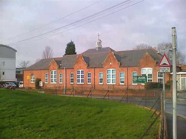 Slade Primary School (Keith Ward)
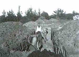 A typical school trench shelter under construction ()
 School children entering a typical trench shelter ()
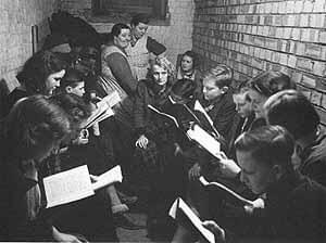 School children receiving lessons in a trench shelter ()
 The only surviving stairway into one of the shelters at Slade Primary School. Note the sump pump on the right hand wall (Nick Catford)
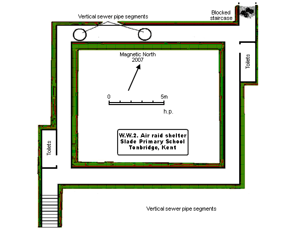 Plan of the smaller of two shelters accessible at Slade Primary School in January 2007. This is designated Shelter No. 1 for the purpose of this report (Harry Pearman)
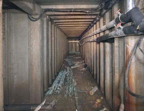 Looking east from the shelter entrance. This is one side of a square with one tunnel to the left in the foreground and another to the left at the end of the tunnel. The pipes and wiring are part of the school heating system (Nick Catford)
 School children in a typical trench shelter lined with corrugated metal panels ()
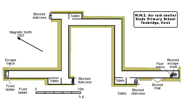 Plan of the larger of two shelters accessible at Slade Primary School in January 2007. This is designated Shelter No. 2 for the purpose of this report (Harry Pearman)
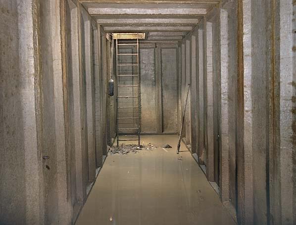 The emergency escape shaft (Nick Catford)
 The only structural damage to the shelter - two of the concrete wall panels have pushed out at the bottom. An emergency exit was sited above the debris at the end of the passage (Nick Catford)
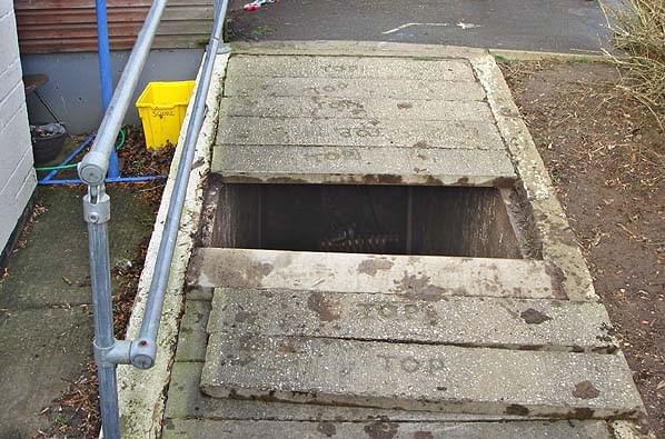 The entrance to No. 1 shelter. This is the only original entrance remaining. The concrete slabs now form part of a sloping path alongside the school building (Bob Jenner)
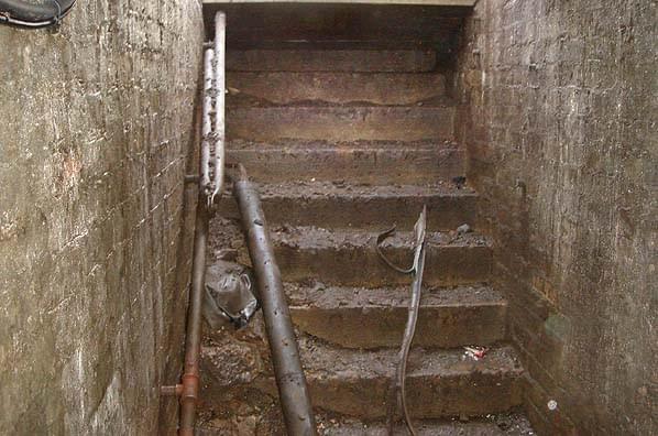 The entrance to No. 1 shelter. This is the only original entrance remaining. Note the hinged hand rail that would have been raised above ground level when the shelter was in use (Bob Jenner)
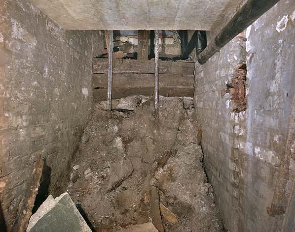 A blocked entrance to No. 1 shelter. Part of the left hand hand rail is still intact (Nick Catford)
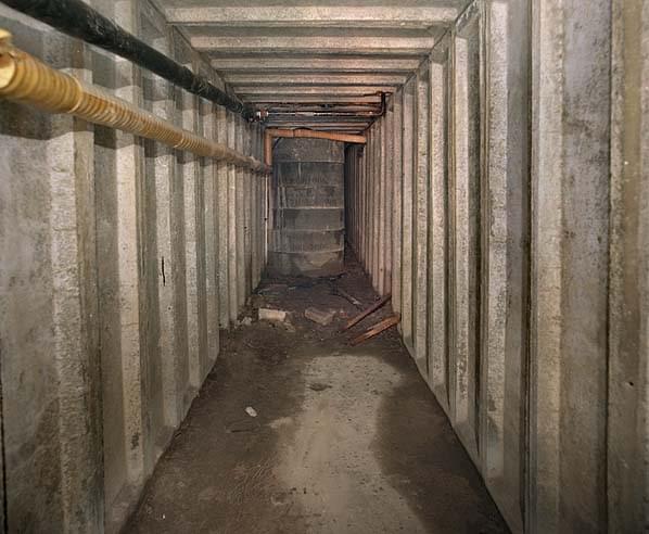 The northern passage in No. 1 shelter. The concrete sewer pipe segments have been placed there in case of future subsidence. The do not reach the roof (Nick Catford)
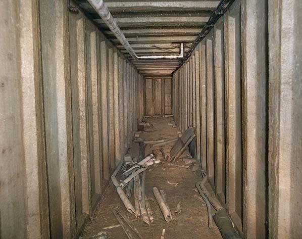 No. 1 shelter - the pipes are part of the heating system for the school (Nick Catford)
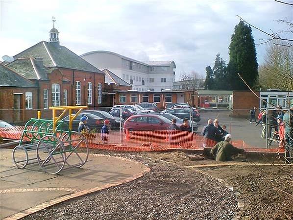 Descending the emergency exit shaft into No. 2 shelter (Keith Ward)
 The emergency exit shaft into No. 2 shelter. The hatch was originally hinged but has now become detached although the mechanism is still in place (Nick Catford)
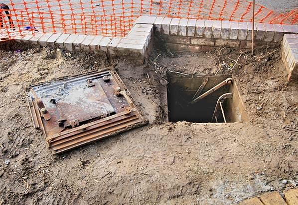 The emergency exit shaft into No. 2 shelter. The hatch was originally hinged but has now become detached although the mechanism is still in place (Nick Catford)
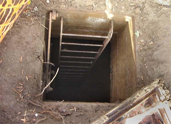 The emergency exit shaft into No. 2 shelter (Bob Jenner)
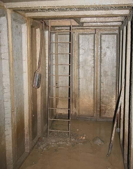 The emergency exit shaft into No. 2 shelter. The counterbalance weight for the hatch is still in place (Nick Catford)
 Metal channel at each entrance would have supported wooden shuttering for gas protection (Nick Catford)
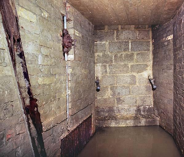 The north east blocked entrance to No 2. Note the metal channel for the wooden shuttering for gas protection. The sump grill and pump can also be seen together with the ends of the two hand rails projecting through the well (Nick Catford)
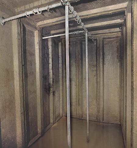 Three toilet cubicles in a recess in the north east corner of No. 2 shelter. The rails would have supported curtains for privacy (Nick Catford)
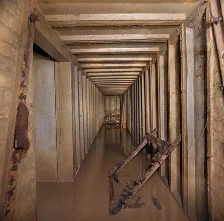 Looking towards the blocked emergency exit in No. 2 shelter. The metal channel for supporting the gas shuttering can be seen on each side. The wood leaning against the wall might be part of the shuttering (Nick Catford)
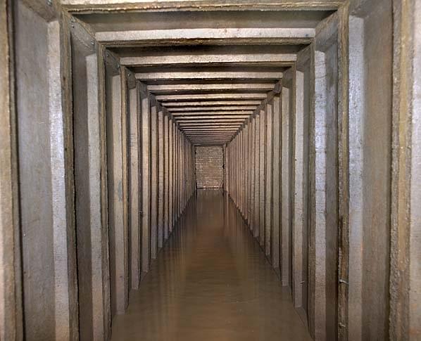 No. 2 shelter (Nick Catford)
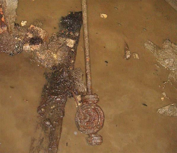 One of the sump pumps in No. 2 shelter (Bob Jenner)
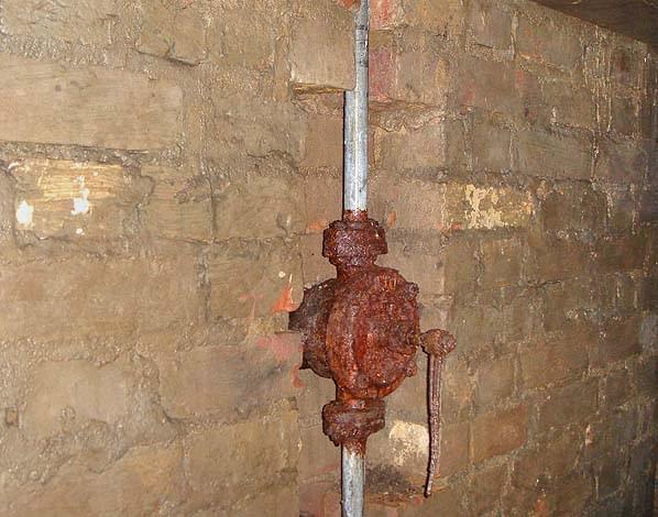 One of the sump pumps in No. 2 shelter (Bob Jenner)
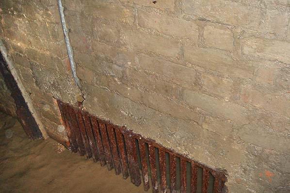 One of the sump grills in No. 2 shelter (Bob Jenner)