Loading map...
{"minzoom":false,"maxzoom":false,"mappingservice":"leaflet","width":"auto","height":"600px","centre":{"text":"","title":"","link":"","lat":51.123072,"lon":0.257773,"icon":""},"title":"","label":"","icon":"","lines":[],"polygons":[],"circles":[],"rectangles":[],"copycoords":false,"static":false,"zoom":false,"defzoom":14,"layers":["OpenStreetMap","Esri.WorldImagery"],"image layers":[],"overlays":[],"resizable":false,"fullscreen":true,"scrollwheelzoom":true,"cluster":false,"clustermaxzoom":20,"clusterzoomonclick":true,"clustermaxradius":1,"clusterspiderfy":true,"geojson":"","clicktarget":"","imageLayers":[],"locations":[{"text":"\u003Cb\u003E\u003Cdiv class=\"mw-parser-output\"\u003E\u003Cp\u003E\u003Ca href=\"/northfleet-kilns\" title=\"northfleet-kilns\"\u003ENorthfleet Kilns\u003C/a\u003E\u003C/b\u003E\u003Cdiv class=\"mw-parser-output\"\u003E\u003Cp\u003E\u003Ca href=\"/Category:factories-and-storage\" title=\"Category:factories-and-storage\"\u003EFactories and Storage\u003C/a\u003E, \u003Ca href=\"/Category:civil-defence\" title=\"Category:civil-defence\"\u003ECivil Defence\u003C/a\u003E, \u003Ca href=\"/Category:transport\" title=\"Category:transport\"\u003ETransport\u003C/a\u003E\n\u003C/p\u003E\u003C/div\u003E","title":"Northfleet Kilns@Factories and Storage, Civil Defence, Transport\n","link":"","lat":51.448,"lon":0.329,"icon":"/images/4/40/m_factories-and-storage.png"},{"text":"\u003Cb\u003E\u003Cdiv class=\"mw-parser-output\"\u003E\u003Cp\u003E\u003Ca href=\"/coldblow-ace-high-relay-station\" title=\"coldblow-ace-high-relay-station\"\u003EColdblow Ace High Relay Station\u003C/a\u003E\u003C/b\u003E\u003Cdiv class=\"mw-parser-output\"\u003E\u003Cp\u003E\u003Ca href=\"/Category:radar\" title=\"Category:radar\"\u003ERadar\u003C/a\u003E\n\u003C/p\u003E\u003C/div\u003E","title":"Coldblow Ace High Relay Station@Radar\n","link":"","lat":51.296,"lon":0.615,"icon":"/images/e/ef/m_radar.png"},{"text":"\u003Cb\u003E\u003Cdiv class=\"mw-parser-output\"\u003E\u003Cp\u003E\u003Ca href=\"/chatham-southern-water-emergency-control-centre\" title=\"chatham-southern-water-emergency-control-centre\"\u003EChatham Southern Water Emergency Control Centre\u003C/a\u003E\u003C/b\u003E\u003Cdiv class=\"mw-parser-output\"\u003E\u003Cp\u003E\u003Ca href=\"/Category:nuclear-bunkers\" title=\"Category:nuclear-bunkers\"\u003ENuclear Bunkers\u003C/a\u003E, \u003Ca href=\"/Category:sewers-sanitation-and-water\" title=\"Category:sewers-sanitation-and-water\"\u003ESewers, Sanitation and Water\u003C/a\u003E\n\u003C/p\u003E\u003C/div\u003E","title":"Chatham Southern Water Emergency Control Centre@Nuclear Bunkers, Sewers, Sanitation and Water\n","link":"","lat":51.337,"lon":0.613,"icon":"/images/d/d0/m_nuclear-bunkers.png"},{"text":"\u003Cb\u003E\u003Cdiv class=\"mw-parser-output\"\u003E\u003Cp\u003E\u003Ca href=\"/hoo-fort\" title=\"hoo-fort\"\u003EHoo Fort\u003C/a\u003E\u003C/b\u003E\u003Cdiv class=\"mw-parser-output\"\u003E\u003Cp\u003E\u003Ca href=\"/Category:military-land\" title=\"Category:military-land\"\u003EMilitary - Land\u003C/a\u003E\n\u003C/p\u003E\u003C/div\u003E","title":"Hoo Fort@Military - Land\n","link":"","lat":51.403,"lon":0.582,"icon":"/images/2/2c/m_military-land.png"},{"text":"\u003Cb\u003E\u003Cdiv class=\"mw-parser-output\"\u003E\u003Cp\u003E\u003Ca href=\"/darnley-mausoleum\" title=\"darnley-mausoleum\"\u003EDarnley Mausoleum\u003C/a\u003E\u003C/b\u003E\u003Cdiv class=\"mw-parser-output\"\u003E\u003Cp\u003E\u003Ca href=\"/Category:places-to-visit\" title=\"Category:places-to-visit\"\u003EPlaces To Visit\u003C/a\u003E, \u003Ca href=\"/Category:religious-and-burial\" title=\"Category:religious-and-burial\"\u003EReligious and Burial\u003C/a\u003E\n\u003C/p\u003E\u003C/div\u003E","title":"Darnley Mausoleum@Places To Visit, Religious and Burial\n","link":"","lat":51.389,"lon":0.434,"icon":"v_places-to-visit.png"},{"text":"\u003Cb\u003E\u003Cdiv class=\"mw-parser-output\"\u003E\u003Cp\u003E\u003Ca href=\"/tenterden-roc-post\" title=\"tenterden-roc-post\"\u003ETenterden ROC Post\u003C/a\u003E\u003C/b\u003E\u003Cdiv class=\"mw-parser-output\"\u003E\u003Cp\u003E\u003Ca href=\"/Category:nuclear-monitoring-posts\" title=\"Category:nuclear-monitoring-posts\"\u003ENuclear Monitoring Posts\u003C/a\u003E\n\u003C/p\u003E\u003C/div\u003E","title":"Tenterden ROC Post@Nuclear Monitoring Posts\n","link":"","lat":51.082,"lon":0.673,"icon":"/images/4/4c/m_nuclear-monitoring-posts.png"},{"text":"\u003Cb\u003E\u003Cdiv class=\"mw-parser-output\"\u003E\u003Cp\u003E\u003Ca href=\"/rainham-kent-roc-post\" title=\"rainham-kent-roc-post\"\u003ERainham (Kent) ROC Post\u003C/a\u003E\u003C/b\u003E\u003Cdiv class=\"mw-parser-output\"\u003E\u003Cp\u003E\u003Ca href=\"/Category:nuclear-monitoring-posts\" title=\"Category:nuclear-monitoring-posts\"\u003ENuclear Monitoring Posts\u003C/a\u003E\n\u003C/p\u003E\u003C/div\u003E","title":"Rainham (Kent) ROC Post@Nuclear Monitoring Posts\n","link":"","lat":51.351,"lon":0.611,"icon":"/images/4/4c/m_nuclear-monitoring-posts.png"},{"text":"\u003Cb\u003E\u003Cdiv class=\"mw-parser-output\"\u003E\u003Cp\u003E\u003Ca href=\"/penshurst-roc-post\" title=\"penshurst-roc-post\"\u003EPenshurst ROC Post\u003C/a\u003E\u003C/b\u003E\u003Cdiv class=\"mw-parser-output\"\u003E\u003Cp\u003E\u003Ca href=\"/Category:nuclear-monitoring-posts\" title=\"Category:nuclear-monitoring-posts\"\u003ENuclear Monitoring Posts\u003C/a\u003E\n\u003C/p\u003E\u003C/div\u003E","title":"Penshurst ROC Post@Nuclear Monitoring Posts\n","link":"","lat":51.202,"lon":0.183,"icon":"/images/4/4c/m_nuclear-monitoring-posts.png"},{"text":"\u003Cb\u003E\u003Cdiv class=\"mw-parser-output\"\u003E\u003Cp\u003E\u003Ca href=\"/linton-roc-post\" title=\"linton-roc-post\"\u003ELinton ROC Post\u003C/a\u003E\u003C/b\u003E\u003Cdiv class=\"mw-parser-output\"\u003E\u003Cp\u003E\u003Ca href=\"/Category:nuclear-monitoring-posts\" title=\"Category:nuclear-monitoring-posts\"\u003ENuclear Monitoring Posts\u003C/a\u003E\n\u003C/p\u003E\u003C/div\u003E","title":"Linton ROC Post@Nuclear Monitoring Posts\n","link":"","lat":51.231,"lon":0.525,"icon":"/images/4/4c/m_nuclear-monitoring-posts.png"},{"text":"\u003Cb\u003E\u003Cdiv class=\"mw-parser-output\"\u003E\u003Cp\u003E\u003Ca href=\"/farningham-roc-post\" title=\"farningham-roc-post\"\u003EFarningham ROC Post\u003C/a\u003E\u003C/b\u003E\u003Cdiv class=\"mw-parser-output\"\u003E\u003Cp\u003E\u003Ca href=\"/Category:nuclear-monitoring-posts\" title=\"Category:nuclear-monitoring-posts\"\u003ENuclear Monitoring Posts\u003C/a\u003E\n\u003C/p\u003E\u003C/div\u003E","title":"Farningham ROC Post@Nuclear Monitoring Posts\n","link":"","lat":51.381,"lon":0.202,"icon":"/images/4/4c/m_nuclear-monitoring-posts.png"},{"text":"\u003Cb\u003E\u003Cdiv class=\"mw-parser-output\"\u003E\u003Cp\u003E\u003Ca href=\"/edenbridge-roc-post\" title=\"edenbridge-roc-post\"\u003EEdenbridge ROC Post\u003C/a\u003E\u003C/b\u003E\u003Cdiv class=\"mw-parser-output\"\u003E\u003Cp\u003E\u003Ca href=\"/Category:nuclear-monitoring-posts\" title=\"Category:nuclear-monitoring-posts\"\u003ENuclear Monitoring Posts\u003C/a\u003E\n\u003C/p\u003E\u003C/div\u003E","title":"Edenbridge ROC Post@Nuclear Monitoring Posts\n","link":"","lat":51.198,"lon":0.087,"icon":"/images/4/4c/m_nuclear-monitoring-posts.png"},{"text":"\u003Cb\u003E\u003Cdiv class=\"mw-parser-output\"\u003E\u003Cp\u003E\u003Ca href=\"/cranbrook-roc-post\" title=\"cranbrook-roc-post\"\u003ECranbrook ROC Post\u003C/a\u003E\u003C/b\u003E\u003Cdiv class=\"mw-parser-output\"\u003E\u003Cp\u003E\u003Ca href=\"/Category:nuclear-monitoring-posts\" title=\"Category:nuclear-monitoring-posts\"\u003ENuclear Monitoring Posts\u003C/a\u003E\n\u003C/p\u003E\u003C/div\u003E","title":"Cranbrook ROC Post@Nuclear Monitoring Posts\n","link":"","lat":51.091,"lon":0.516,"icon":"/images/4/4c/m_nuclear-monitoring-posts.png"},{"text":"\u003Cb\u003E\u003Cdiv class=\"mw-parser-output\"\u003E\u003Cp\u003E\u003Ca href=\"/cliffe-roc-post\" title=\"cliffe-roc-post\"\u003ECliffe ROC Post\u003C/a\u003E\u003C/b\u003E\u003Cdiv class=\"mw-parser-output\"\u003E\u003Cp\u003E\u003Ca href=\"/Category:nuclear-monitoring-posts\" title=\"Category:nuclear-monitoring-posts\"\u003ENuclear Monitoring Posts\u003C/a\u003E\n\u003C/p\u003E\u003C/div\u003E","title":"Cliffe ROC Post@Nuclear Monitoring Posts\n","link":"","lat":51.461,"lon":0.492,"icon":"/images/4/4c/m_nuclear-monitoring-posts.png"},{"text":"\u003Cb\u003E\u003Cdiv class=\"mw-parser-output\"\u003E\u003Cp\u003E\u003Ca href=\"/borough-green-roc-post\" title=\"borough-green-roc-post\"\u003EBorough Green ROC Post\u003C/a\u003E\u003C/b\u003E\u003Cdiv class=\"mw-parser-output\"\u003E\u003Cp\u003E\u003Ca href=\"/Category:nuclear-monitoring-posts\" title=\"Category:nuclear-monitoring-posts\"\u003ENuclear Monitoring Posts\u003C/a\u003E\n\u003C/p\u003E\u003C/div\u003E","title":"Borough Green ROC Post@Nuclear Monitoring Posts\n","link":"","lat":51.292,"lon":0.312,"icon":"/images/4/4c/m_nuclear-monitoring-posts.png"},{"text":"\u003Cb\u003E\u003Cdiv class=\"mw-parser-output\"\u003E\u003Cp\u003E\u003Ca href=\"/fort-pitt\" title=\"fort-pitt\"\u003EFort Pitt\u003C/a\u003E\u003C/b\u003E\u003Cdiv class=\"mw-parser-output\"\u003E\u003Cp\u003E\u003Ca href=\"/Category:civil-defence\" title=\"Category:civil-defence\"\u003ECivil Defence\u003C/a\u003E, \u003Ca href=\"/Category:military-land\" title=\"Category:military-land\"\u003EMilitary - Land\u003C/a\u003E\n\u003C/p\u003E\u003C/div\u003E","title":"Fort Pitt@Civil Defence, Military - Land\n","link":"","lat":51.382,"lon":0.514,"icon":"/images/c/c5/m_civil-defence.png"},{"text":"\u003Cb\u003E\u003Cdiv class=\"mw-parser-output\"\u003E\u003Cp\u003E\u003Ca href=\"/st-matthews-school-air-raid-shelter\" title=\"st-matthews-school-air-raid-shelter\"\u003ESt Matthews School Air Raid Shelter\u003C/a\u003E\u003C/b\u003E\u003Cdiv class=\"mw-parser-output\"\u003E\u003Cp\u003E\u003Ca href=\"/Category:civil-defence\" title=\"Category:civil-defence\"\u003ECivil Defence\u003C/a\u003E, \u003Ca href=\"/Category:places-to-visit\" title=\"Category:places-to-visit\"\u003EPlaces To Visit\u003C/a\u003E\n\u003C/p\u003E\u003C/div\u003E","title":"St Matthews School Air Raid Shelter@Civil Defence, Places To Visit\n","link":"","lat":51.153,"lon":0.271,"icon":"/images/3/3e/v_civil-defence.png"},{"text":"\u003Cb\u003E\u003Cdiv class=\"mw-parser-output\"\u003E\u003Cp\u003E\u003Ca href=\"/civil-defence-control-centre-gravesend\" title=\"civil-defence-control-centre-gravesend\"\u003ECivil Defence Control Centre Gravesend\u003C/a\u003E\u003C/b\u003E\u003Cdiv class=\"mw-parser-output\"\u003E\u003Cp\u003E\u003Ca href=\"/Category:military-intelligence-and-communication\" title=\"Category:military-intelligence-and-communication\"\u003EMilitary - Intelligence and Communication\u003C/a\u003E, \u003Ca href=\"/Category:places-to-visit\" title=\"Category:places-to-visit\"\u003EPlaces To Visit\u003C/a\u003E\n\u003C/p\u003E\u003C/div\u003E","title":"Civil Defence Control Centre Gravesend@Military - Intelligence and Communication, Places To Visit\n","link":"","lat":51.431,"lon":0.364,"icon":"/images/6/63/v_military-intelligence-and-communication.png"},{"text":"\u003Cb\u003E\u003Cdiv class=\"mw-parser-output\"\u003E\u003Cp\u003E\u003Ca href=\"/hosey-common-stone-quarry\" title=\"hosey-common-stone-quarry\"\u003EHosey Common Stone Quarry\u003C/a\u003E\u003C/b\u003E\u003Cdiv class=\"mw-parser-output\"\u003E\u003Cp\u003E\u003Ca href=\"/Category:mines\" title=\"Category:mines\"\u003EMines\u003C/a\u003E\n\u003C/p\u003E\u003C/div\u003E","title":"Hosey Common Stone Quarry@Mines\n","link":"","lat":51.256,"lon":0.084,"icon":"/images/a/ae/m_mines.png"},{"text":"\u003Cb\u003E\u003Cdiv class=\"mw-parser-output\"\u003E\u003Cp\u003E\u003Ca href=\"/west-malling-airfield-battle-hq\" title=\"west-malling-airfield-battle-hq\"\u003EWest Malling Airfield Battle HQ\u003C/a\u003E\u003C/b\u003E\u003Cdiv class=\"mw-parser-output\"\u003E\u003Cp\u003E\u003Ca href=\"/Category:military-air\" title=\"Category:military-air\"\u003EMilitary - Air\u003C/a\u003E\n\u003C/p\u003E\u003C/div\u003E","title":"West Malling Airfield Battle HQ@Military - Air\n","link":"","lat":51.265,"lon":0.402,"icon":"/images/4/4e/m_military-air.png"},{"text":"\u003Cb\u003E\u003Cdiv class=\"mw-parser-output\"\u003E\u003Cp\u003E\u003Ca href=\"/detling-airfield-battle-hq\" title=\"detling-airfield-battle-hq\"\u003EDetling Airfield Battle HQ\u003C/a\u003E\u003C/b\u003E\u003Cdiv class=\"mw-parser-output\"\u003E\u003Cp\u003E\u003Ca href=\"/Category:military-air\" title=\"Category:military-air\"\u003EMilitary - Air\u003C/a\u003E\n\u003C/p\u003E\u003C/div\u003E","title":"Detling Airfield Battle HQ@Military - Air\n","link":"","lat":51.311,"lon":0.608,"icon":"/images/4/4e/m_military-air.png"},{"text":"\u003Cb\u003E\u003Cdiv class=\"mw-parser-output\"\u003E\u003Cp\u003E\u003Ca class=\"mw-selflink selflink\"\u003EGrove Tunnel\u003C/a\u003E\u003C/b\u003E\u003Cdiv class=\"mw-parser-output\"\u003E\u003Cp\u003E\u003Ca href=\"/Category:transport\" title=\"Category:transport\"\u003ETransport\u003C/a\u003E\n\u003C/p\u003E\u003C/div\u003E","title":"Grove Tunnel@Transport\n","link":"","lat":51.123,"lon":0.258,"icon":"/images/d/d2/Red-marker.png"},{"text":"\u003Cb\u003E\u003Cdiv class=\"mw-parser-output\"\u003E\u003Cp\u003E\u003Ca href=\"/tunbridge-wells-regional-war-room\" title=\"tunbridge-wells-regional-war-room\"\u003ETunbridge Wells Regional War Room\u003C/a\u003E\u003C/b\u003E\u003Cdiv class=\"mw-parser-output\"\u003E\u003Cp\u003E\u003Ca href=\"/Category:government-national-and-regional\" title=\"Category:government-national-and-regional\"\u003EGovernment - National and Regional\u003C/a\u003E, \u003Ca href=\"/Category:nuclear-bunkers\" title=\"Category:nuclear-bunkers\"\u003ENuclear Bunkers\u003C/a\u003E\n\u003C/p\u003E\u003C/div\u003E","title":"Tunbridge Wells Regional War Room@Government - National and Regional, Nuclear Bunkers\n","link":"","lat":51.126,"lon":0.279,"icon":"/images/d/d7/m_government-national-and-regional.png"},{"text":"\u003Cb\u003E\u003Cdiv class=\"mw-parser-output\"\u003E\u003Cp\u003E\u003Ca href=\"/maidstone-springfields-kent-county-emergency-centre\" title=\"maidstone-springfields-kent-county-emergency-centre\"\u003EMaidstone Springfields Kent County Emergency Centre\u003C/a\u003E\u003C/b\u003E\u003Cdiv class=\"mw-parser-output\"\u003E\u003Cp\u003E\u003Ca href=\"/Category:government-local\" title=\"Category:government-local\"\u003EGovernment - Local\u003C/a\u003E, \u003Ca href=\"/Category:nuclear-bunkers\" title=\"Category:nuclear-bunkers\"\u003ENuclear Bunkers\u003C/a\u003E\n\u003C/p\u003E\u003C/div\u003E","title":"Maidstone Springfields Kent County Emergency Centre@Government - Local, Nuclear Bunkers\n","link":"","lat":51.285,"lon":0.516,"icon":"/images/3/32/m_government-local.png"},{"text":"\u003Cb\u003E\u003Cdiv class=\"mw-parser-output\"\u003E\u003Cp\u003E\u003Ca href=\"/gillingham-borough-control\" title=\"gillingham-borough-control\"\u003EGillingham Borough Control\u003C/a\u003E\u003C/b\u003E\u003Cdiv class=\"mw-parser-output\"\u003E\u003Cp\u003E\u003Ca href=\"/Category:government-local\" title=\"Category:government-local\"\u003EGovernment - Local\u003C/a\u003E, \u003Ca href=\"/Category:nuclear-bunkers\" title=\"Category:nuclear-bunkers\"\u003ENuclear Bunkers\u003C/a\u003E\n\u003C/p\u003E\u003C/div\u003E","title":"Gillingham Borough Control@Government - Local, Nuclear Bunkers\n","link":"","lat":51.376,"lon":0.553,"icon":"/images/3/32/m_government-local.png"},{"text":"\u003Cb\u003E\u003Cdiv class=\"mw-parser-output\"\u003E\u003Cp\u003E\u003Ca href=\"/dartford-emergency-centre\" title=\"dartford-emergency-centre\"\u003EDartford Emergency Centre\u003C/a\u003E\u003C/b\u003E\u003Cdiv class=\"mw-parser-output\"\u003E\u003Cp\u003E\u003Ca href=\"/Category:government-local\" title=\"Category:government-local\"\u003EGovernment - Local\u003C/a\u003E, \u003Ca href=\"/Category:nuclear-bunkers\" title=\"Category:nuclear-bunkers\"\u003ENuclear Bunkers\u003C/a\u003E\n\u003C/p\u003E\u003C/div\u003E","title":"Dartford Emergency Centre@Government - Local, Nuclear Bunkers\n","link":"","lat":51.447,"lon":0.219,"icon":"/images/3/32/m_government-local.png"},{"text":"\u003Cb\u003E\u003Cdiv class=\"mw-parser-output\"\u003E\u003Cp\u003E\u003Ca href=\"/darenth-wood-dene-hole\" title=\"darenth-wood-dene-hole\"\u003EDarenth Wood Dene Hole\u003C/a\u003E\u003C/b\u003E\u003Cdiv class=\"mw-parser-output\"\u003E\u003Cp\u003E\u003Ca href=\"/Category:mines\" title=\"Category:mines\"\u003EMines\u003C/a\u003E\n\u003C/p\u003E\u003C/div\u003E","title":"Darenth Wood Dene Hole@Mines\n","link":"","lat":51.43,"lon":0.267,"icon":"/images/a/ae/m_mines.png"},{"text":"\u003Cb\u003E\u003Cdiv class=\"mw-parser-output\"\u003E\u003Cp\u003E\u003Ca href=\"/wateringbury-roc-post\" title=\"wateringbury-roc-post\"\u003EWateringbury ROC Post\u003C/a\u003E\u003C/b\u003E\u003Cdiv class=\"mw-parser-output\"\u003E\u003Cp\u003E\u003Ca href=\"/Category:nuclear-monitoring-posts\" title=\"Category:nuclear-monitoring-posts\"\u003ENuclear Monitoring Posts\u003C/a\u003E\n\u003C/p\u003E\u003C/div\u003E","title":"Wateringbury ROC Post@Nuclear Monitoring Posts\n","link":"","lat":51.246,"lon":0.4,"icon":"/images/4/4c/m_nuclear-monitoring-posts.png"},{"text":"\u003Cb\u003E\u003Cdiv class=\"mw-parser-output\"\u003E\u003Cp\u003E\u003Ca href=\"/snodland-roc-post\" title=\"snodland-roc-post\"\u003ESnodland ROC Post\u003C/a\u003E\u003C/b\u003E\u003Cdiv class=\"mw-parser-output\"\u003E\u003Cp\u003E\u003Ca href=\"/Category:nuclear-monitoring-posts\" title=\"Category:nuclear-monitoring-posts\"\u003ENuclear Monitoring Posts\u003C/a\u003E\n\u003C/p\u003E\u003C/div\u003E","title":"Snodland ROC Post@Nuclear Monitoring Posts\n","link":"","lat":51.323,"lon":0.432,"icon":"/images/4/4c/m_nuclear-monitoring-posts.png"},{"text":"\u003Cb\u003E\u003Cdiv class=\"mw-parser-output\"\u003E\u003Cp\u003E\u003Ca href=\"/horsmonden-roc-post\" title=\"horsmonden-roc-post\"\u003EHorsmonden ROC Post\u003C/a\u003E\u003C/b\u003E\u003Cdiv class=\"mw-parser-output\"\u003E\u003Cp\u003E\u003Ca href=\"/Category:nuclear-monitoring-posts\" title=\"Category:nuclear-monitoring-posts\"\u003ENuclear Monitoring Posts\u003C/a\u003E\n\u003C/p\u003E\u003C/div\u003E","title":"Horsmonden ROC Post@Nuclear Monitoring Posts\n","link":"","lat":51.121,"lon":0.425,"icon":"/images/4/4c/m_nuclear-monitoring-posts.png"},{"text":"\u003Cb\u003E\u003Cdiv class=\"mw-parser-output\"\u003E\u003Cp\u003E\u003Ca href=\"/headcorn-roc-post\" title=\"headcorn-roc-post\"\u003EHeadcorn ROC Post\u003C/a\u003E\u003C/b\u003E\u003Cdiv class=\"mw-parser-output\"\u003E\u003Cp\u003E\u003Ca href=\"/Category:nuclear-monitoring-posts\" title=\"Category:nuclear-monitoring-posts\"\u003ENuclear Monitoring Posts\u003C/a\u003E\n\u003C/p\u003E\u003C/div\u003E","title":"Headcorn ROC Post@Nuclear Monitoring Posts\n","link":"","lat":51.171,"lon":0.616,"icon":"/images/4/4c/m_nuclear-monitoring-posts.png"},{"text":"\u003Cb\u003E\u003Cdiv class=\"mw-parser-output\"\u003E\u003Cp\u003E\u003Ca href=\"/greenhithe-roc-post\" title=\"greenhithe-roc-post\"\u003EGreenhithe ROC Post\u003C/a\u003E\u003C/b\u003E\u003Cdiv class=\"mw-parser-output\"\u003E\u003Cp\u003E\u003Ca href=\"/Category:nuclear-monitoring-posts\" title=\"Category:nuclear-monitoring-posts\"\u003ENuclear Monitoring Posts\u003C/a\u003E\n\u003C/p\u003E\u003C/div\u003E","title":"Greenhithe ROC Post@Nuclear Monitoring Posts\n","link":"","lat":51.437,"lon":0.312,"icon":"/images/4/4c/m_nuclear-monitoring-posts.png"},{"text":"\u003Cb\u003E\u003Cdiv class=\"mw-parser-output\"\u003E\u003Cp\u003E\u003Ca href=\"/brasted-roc-post\" title=\"brasted-roc-post\"\u003EBrasted ROC Post\u003C/a\u003E\u003C/b\u003E\u003Cdiv class=\"mw-parser-output\"\u003E\u003Cp\u003E\u003Ca href=\"/Category:nuclear-monitoring-posts\" title=\"Category:nuclear-monitoring-posts\"\u003ENuclear Monitoring Posts\u003C/a\u003E\n\u003C/p\u003E\u003C/div\u003E","title":"Brasted ROC Post@Nuclear Monitoring Posts\n","link":"","lat":51.29,"lon":0.106,"icon":"/images/4/4c/m_nuclear-monitoring-posts.png"},{"text":"\u003Cb\u003E\u003Cdiv class=\"mw-parser-output\"\u003E\u003Cp\u003E\u003Ca href=\"/bearsted-roc-post\" title=\"bearsted-roc-post\"\u003EBearsted ROC Post\u003C/a\u003E\u003C/b\u003E\u003Cdiv class=\"mw-parser-output\"\u003E\u003Cp\u003E\u003Ca href=\"/Category:nuclear-monitoring-posts\" title=\"Category:nuclear-monitoring-posts\"\u003ENuclear Monitoring Posts\u003C/a\u003E\n\u003C/p\u003E\u003C/div\u003E","title":"Bearsted ROC Post@Nuclear Monitoring Posts\n","link":"","lat":51.275,"lon":0.573,"icon":"/images/4/4c/m_nuclear-monitoring-posts.png"},{"text":"\u003Cb\u003E\u003Cdiv class=\"mw-parser-output\"\u003E\u003Cp\u003E\u003Ca href=\"/fort-bridgewoods-aaor\" title=\"fort-bridgewoods-aaor\"\u003EFort Bridgewoods AAOR\u003C/a\u003E\u003C/b\u003E\u003Cdiv class=\"mw-parser-output\"\u003E\u003Cp\u003E\u003Ca href=\"/Category:military-land\" title=\"Category:military-land\"\u003EMilitary - Land\u003C/a\u003E, \u003Ca href=\"/Category:nuclear-bunkers\" title=\"Category:nuclear-bunkers\"\u003ENuclear Bunkers\u003C/a\u003E\n\u003C/p\u003E\u003C/div\u003E","title":"Fort Bridgewoods AAOR@Military - Land, Nuclear Bunkers\n","link":"","lat":51.36,"lon":0.494,"icon":"/images/2/2c/m_military-land.png"},{"text":"\u003Cb\u003E\u003Cdiv class=\"mw-parser-output\"\u003E\u003Cp\u003E\u003Ca href=\"/lullingstone-castle-ice-house\" title=\"lullingstone-castle-ice-house\"\u003ELullingstone Castle Ice House\u003C/a\u003E\u003C/b\u003E\u003Cdiv class=\"mw-parser-output\"\u003E\u003Cp\u003E\u003Ca href=\"/Category:ice-wells\" title=\"Category:ice-wells\"\u003EIce Wells\u003C/a\u003E\n\u003C/p\u003E\u003C/div\u003E","title":"Lullingstone Castle Ice House@Ice Wells\n","link":"","lat":51.357,"lon":0.198,"icon":"/images/d/d4/m_ice-wells.png"},{"text":"\u003Cb\u003E\u003Cdiv class=\"mw-parser-output\"\u003E\u003Cp\u003E\u003Ca href=\"/chatham-dockyard-commissioners-house\" title=\"chatham-dockyard-commissioners-house\"\u003EChatham Dockyard Commissioner's House Ice House\u003C/a\u003E\u003C/b\u003E\u003Cdiv class=\"mw-parser-output\"\u003E\u003Cp\u003E\u003Ca href=\"/Category:ice-wells\" title=\"Category:ice-wells\"\u003EIce Wells\u003C/a\u003E\n\u003C/p\u003E\u003C/div\u003E","title":"Chatham Dockyard Commissioner's House Ice House@Ice Wells\n","link":"","lat":51.394,"lon":0.527,"icon":"/images/d/d4/m_ice-wells.png"},{"text":"\u003Cb\u003E\u003Cdiv class=\"mw-parser-output\"\u003E\u003Cp\u003E\u003Ca href=\"/knole-house-ice-well\" title=\"knole-house-ice-well\"\u003EKnole House Ice Well\u003C/a\u003E\u003C/b\u003E\u003Cdiv class=\"mw-parser-output\"\u003E\u003Cp\u003E\u003Ca href=\"/Category:ice-wells\" title=\"Category:ice-wells\"\u003EIce Wells\u003C/a\u003E\n\u003C/p\u003E\u003C/div\u003E","title":"Knole House Ice Well@Ice Wells\n","link":"","lat":51.266,"lon":0.206,"icon":"/images/d/d4/m_ice-wells.png"},{"text":"\u003Cb\u003E\u003Cdiv class=\"mw-parser-output\"\u003E\u003Cp\u003E\u003Ca href=\"/hms-wildfire\" title=\"hms-wildfire\"\u003EHMS Wildfire\u003C/a\u003E\u003C/b\u003E\u003Cdiv class=\"mw-parser-output\"\u003E\u003Cp\u003E\u003Ca href=\"/Category:military-sea\" title=\"Category:military-sea\"\u003EMilitary - Sea\u003C/a\u003E, \u003Ca href=\"/Category:military-air\" title=\"Category:military-air\"\u003EMilitary - Air\u003C/a\u003E\n\u003C/p\u003E\u003C/div\u003E","title":"HMS Wildfire@Military - Sea, Military - Air\n","link":"","lat":51.395,"lon":0.544,"icon":"/images/6/6b/m_military-sea.png"},{"text":"\u003Cb\u003E\u003Cdiv class=\"mw-parser-output\"\u003E\u003Cp\u003E\u003Ca href=\"/hoo-roc-post\" title=\"hoo-roc-post\"\u003EHoo ROC Post\u003C/a\u003E\u003C/b\u003E\u003Cdiv class=\"mw-parser-output\"\u003E\u003Cp\u003E\u003Ca href=\"/Category:nuclear-monitoring-posts\" title=\"Category:nuclear-monitoring-posts\"\u003ENuclear Monitoring Posts\u003C/a\u003E\n\u003C/p\u003E\u003C/div\u003E","title":"Hoo ROC Post@Nuclear Monitoring Posts\n","link":"","lat":51.432,"lon":0.557,"icon":"/images/4/4c/m_nuclear-monitoring-posts.png"},{"text":"\u003Cb\u003E\u003Cdiv class=\"mw-parser-output\"\u003E\u003Cp\u003E\u003Ca href=\"/fort-amherst\" title=\"fort-amherst\"\u003EFort Amherst\u003C/a\u003E\u003C/b\u003E\u003Cdiv class=\"mw-parser-output\"\u003E\u003Cp\u003E\u003Ca href=\"/Category:military-land\" title=\"Category:military-land\"\u003EMilitary - Land\u003C/a\u003E, \u003Ca href=\"/Category:places-to-visit\" title=\"Category:places-to-visit\"\u003EPlaces To Visit\u003C/a\u003E\n\u003C/p\u003E\u003C/div\u003E","title":"Fort Amherst@Military - Land, Places To Visit\n","link":"","lat":51.387,"lon":0.525,"icon":"/images/5/5a/v_military-land.png"},{"text":"\u003Cb\u003E\u003Cdiv class=\"mw-parser-output\"\u003E\u003Cp\u003E\u003Ca href=\"/maidstone-roc-group-hq\" title=\"maidstone-roc-group-hq\"\u003EMaidstone ROC Group HQ\u003C/a\u003E\u003C/b\u003E\u003Cdiv class=\"mw-parser-output\"\u003E\u003Cp\u003E\u003Ca href=\"/Category:military-air\" title=\"Category:military-air\"\u003EMilitary - Air\u003C/a\u003E, \u003Ca href=\"/Category:nuclear-bunkers\" title=\"Category:nuclear-bunkers\"\u003ENuclear Bunkers\u003C/a\u003E\n\u003C/p\u003E\u003C/div\u003E","title":"Maidstone ROC Group HQ@Military - Air, Nuclear Bunkers\n","link":"","lat":51.277,"lon":0.508,"icon":"/images/4/4e/m_military-air.png"},{"text":"\u003Cb\u003E\u003Cdiv class=\"mw-parser-output\"\u003E\u003Cp\u003E\u003Ca href=\"/george-vaults-rochester\" title=\"george-vaults-rochester\"\u003EGeorge Vaults Rochester\u003C/a\u003E\u003C/b\u003E\u003Cdiv class=\"mw-parser-output\"\u003E\u003Cp\u003E\u003Ca href=\"/Category:factories-and-storage\" title=\"Category:factories-and-storage\"\u003EFactories and Storage\u003C/a\u003E, \u003Ca href=\"/Category:places-to-visit\" title=\"Category:places-to-visit\"\u003EPlaces To Visit\u003C/a\u003E\n\u003C/p\u003E\u003C/div\u003E","title":"George Vaults Rochester@Factories and Storage, Places To Visit\n","link":"","lat":51.39,"lon":0.503,"icon":"/images/2/25/v_factories-and-storage.png"},{"text":"\u003Cb\u003E\u003Cdiv class=\"mw-parser-output\"\u003E\u003Cp\u003E\u003Ca href=\"/tonbridge-slade-school-air-raid-shelter\" title=\"tonbridge-slade-school-air-raid-shelter\"\u003ETonbridge Slade School Air Raid Shelter\u003C/a\u003E\u003C/b\u003E\u003Cdiv class=\"mw-parser-output\"\u003E\u003Cp\u003E\u003Ca href=\"/Category:civil-defence\" title=\"Category:civil-defence\"\u003ECivil Defence\u003C/a\u003E\n\u003C/p\u003E\u003C/div\u003E","title":"Tonbridge Slade School Air Raid Shelter@Civil Defence\n","link":"","lat":51.197,"lon":0.271,"icon":"/images/c/c5/m_civil-defence.png"},{"text":"\u003Cb\u003E\u003Cdiv class=\"mw-parser-output\"\u003E\u003Cp\u003E\u003Ca href=\"/rochester-shorts-brothers-factory-and-public-air-raid-shelter\" title=\"rochester-shorts-brothers-factory-and-public-air-raid-shelter\"\u003ERochester Shorts Brothers Factory and Public Air Raid Shelter\u003C/a\u003E\u003C/b\u003E\u003Cdiv class=\"mw-parser-output\"\u003E\u003Cp\u003E\u003Ca href=\"/Category:civil-defence\" title=\"Category:civil-defence\"\u003ECivil Defence\u003C/a\u003E, \u003Ca href=\"/Category:factories-and-storage\" title=\"Category:factories-and-storage\"\u003EFactories and Storage\u003C/a\u003E\n\u003C/p\u003E\u003C/div\u003E","title":"Rochester Shorts Brothers Factory and Public Air Raid Shelter@Civil Defence, Factories and Storage\n","link":"","lat":51.384,"lon":0.498,"icon":"/images/c/c5/m_civil-defence.png"}],"imageoverlays":null}
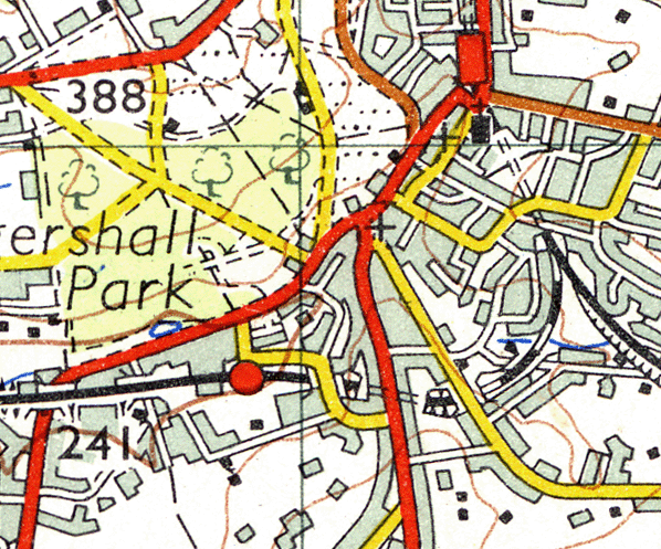 1960s One Inch Ordnance Survey Map showing the path of the track between the two stations and through the tunnel ()
 This image from the 1980s shows the tunnel with the 'B' signal box, the platform ends and the road bridge with its brick parapets still in place. The bridge, which carries Montacute Road, has now been remodelled with a modern concrete parapet (Nick Pullen)
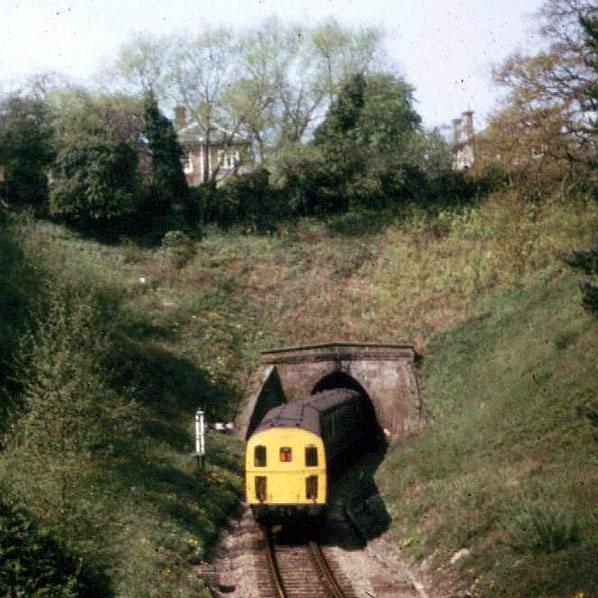 In the same month that the closure notices went up (August 1982), a 'Thumper' emerges from the tunnel drawing the Eridge service and slowly approaches the B box where the driver will give up his single line token (Clive Standen)
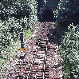 The view towards Grove Junction and Tunbridge Wells a few days before the end, in July 1985. Note the severe speed restrictions - as shown on the blue warning boards - and the poor condition of the trackbed, with very little ballast showing through all the mud. This line has been, quite literally, driven into the ground ()
 The mid-1970s and a driver's eye view of the signalman at Tunbridge Wells West B box, about to hand over the single line token for the short section to Grove Junction through the tunnel (John Wenham)
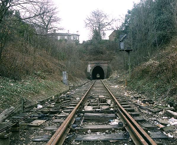 This image, shot in March 1986 like the rest of this series, shows the track still in situ nearly a year after closure. This is the western portal (Nick Catford)
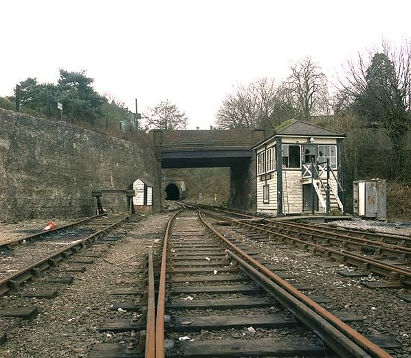 The western portal from the end of the old platform and showing the 'B' signal box beginning to deteriorate at the hands of vandals. The closed line was freely accessible at this time despite the fact that a short walk through the tunnel would take to the main Hastings Line at Grove Junction (Nick Catford)
 A portrait of the tunnel interior using the light painting technique. The photographer has inadvertantly recorded his own progress along the tunnel with background light and each of the grey 'ghosts' shows the points where he stopped to fire a flash gun, thereby creating this overlaid multiple exposure.' (Nick Catford)
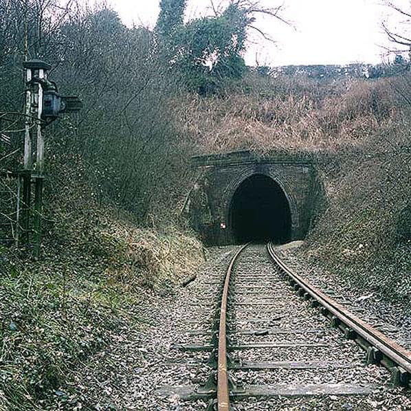 The Eastern portal with the bankside vegetation beginning to encroach on the ballast formation (Nick Catford)
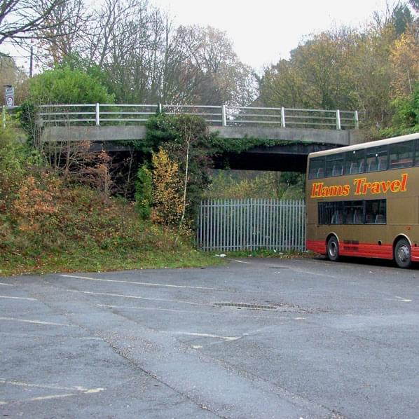 This is a view of the Montacute Road bridge with its new parapet, the entrance to the trackbed is on the bank to the left of the pallisade fence. A derelict old platelayers' cabin still sits in the arch of the bridge and by scrambling over the top of it, one can drop down onto the trackbed (John Smiles)
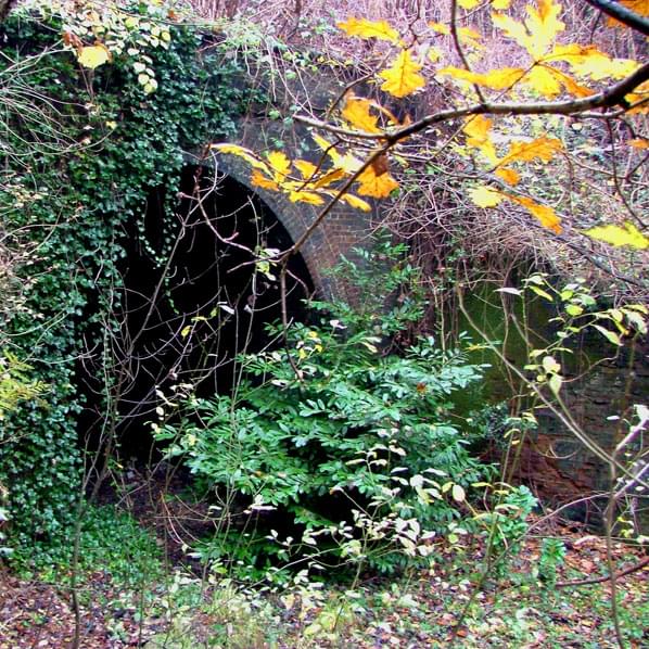 The western portal is now largely obscured from the roadbridge by trees, all of which have regrown since they were cleared to make way for bank stabilisation works in 2000 after the cutting sides began to slip and threaten the houses above (John Smiles)
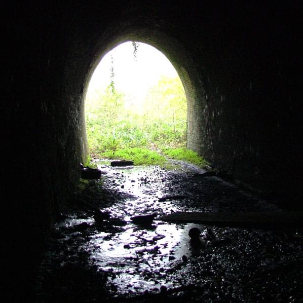 Just inside the western portal, the trackbed is waterlogged. This whole area of Tunbridge Wells is littered with mineral springs, the source of the town's status as a Royal spa. These springs are all chalybeate, a term which means bearing or tasting of iron but is often thought to be the name of each individual spring, causing visitors to ask why they were all named the same (John Smiles)
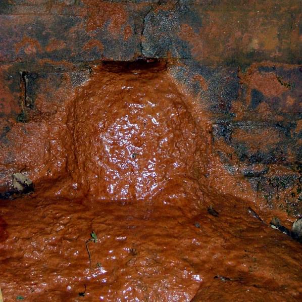 This shows just how chalybeate they are. This thick rusty goo is seeping from a small occlusion in the tunnel's brickwork and has formed a slick of bright red mud that covers the floor (John Smiles)
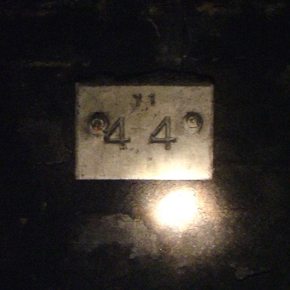 This engineers' datum plate records the exact position and cant (tilt) of the track, measurements that are far more critical inside tunnels where being out of gauge means that the train will hit the walls (John Smiles)
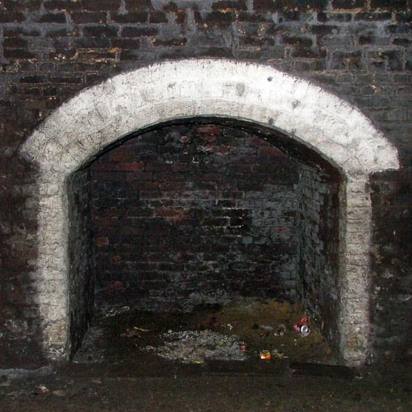 One of the unusually wide trackworkers' refuges inside the bore (Nick Catford)
 Severe spalling of the brickwork just inside the eastern portal may be the first signs of the tunnel's inevitable demise (John Smiles)
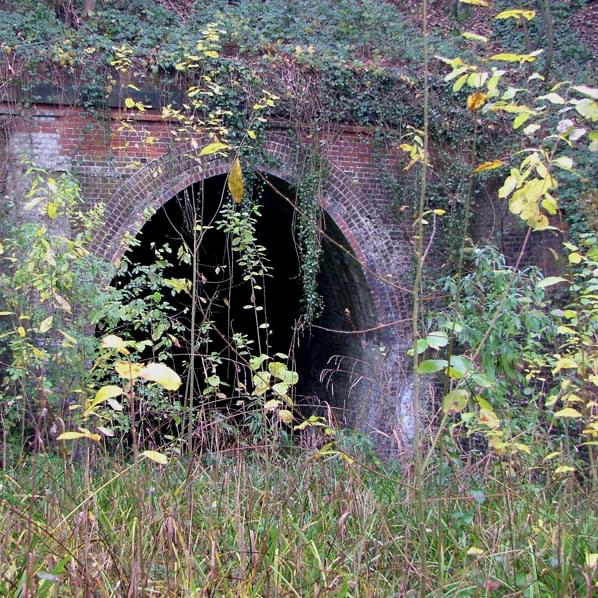 The Eastern portal and trackbed which now form an ad hoc nature reserve (John Smiles)